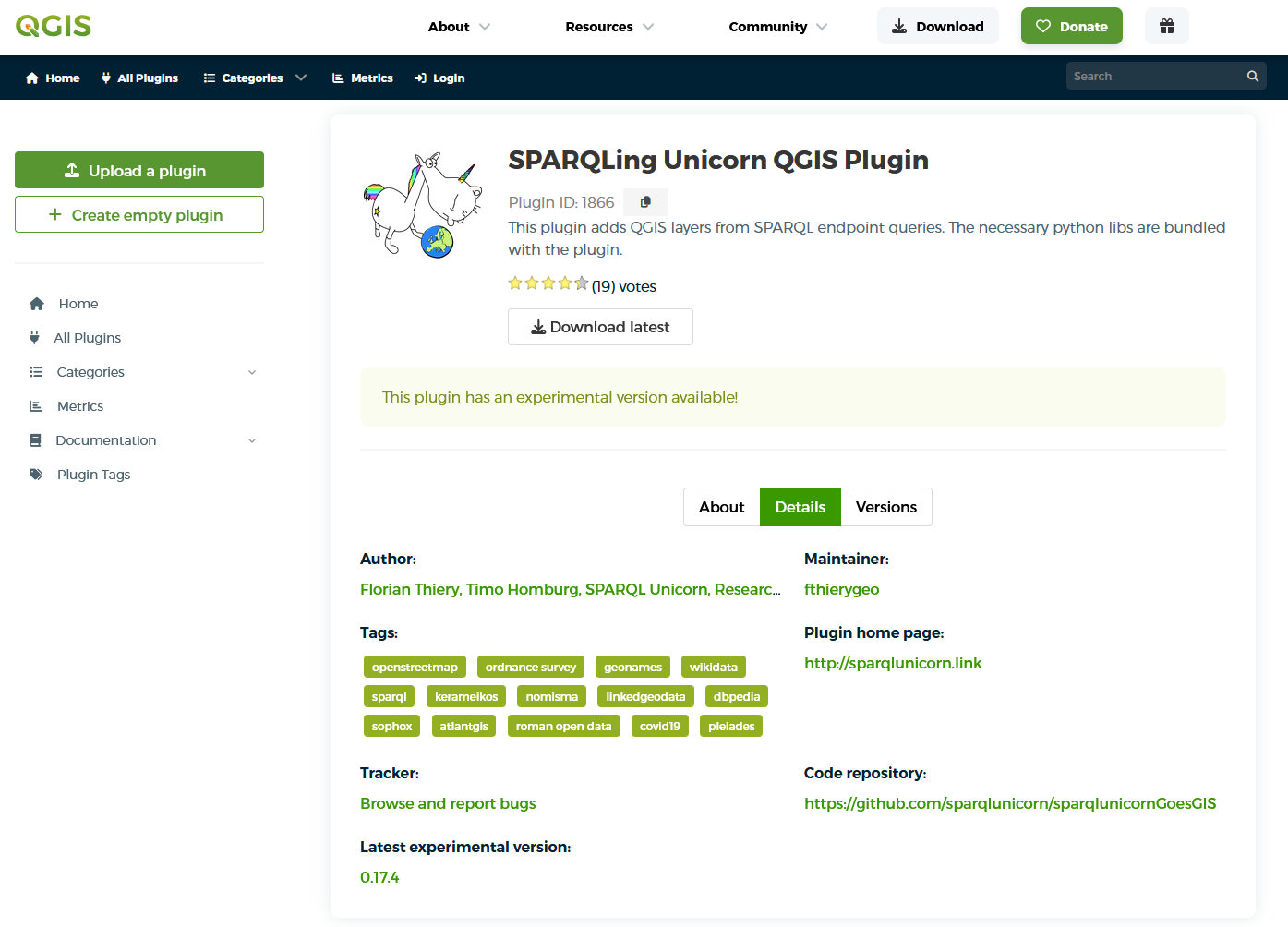
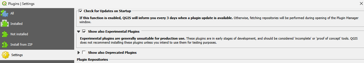
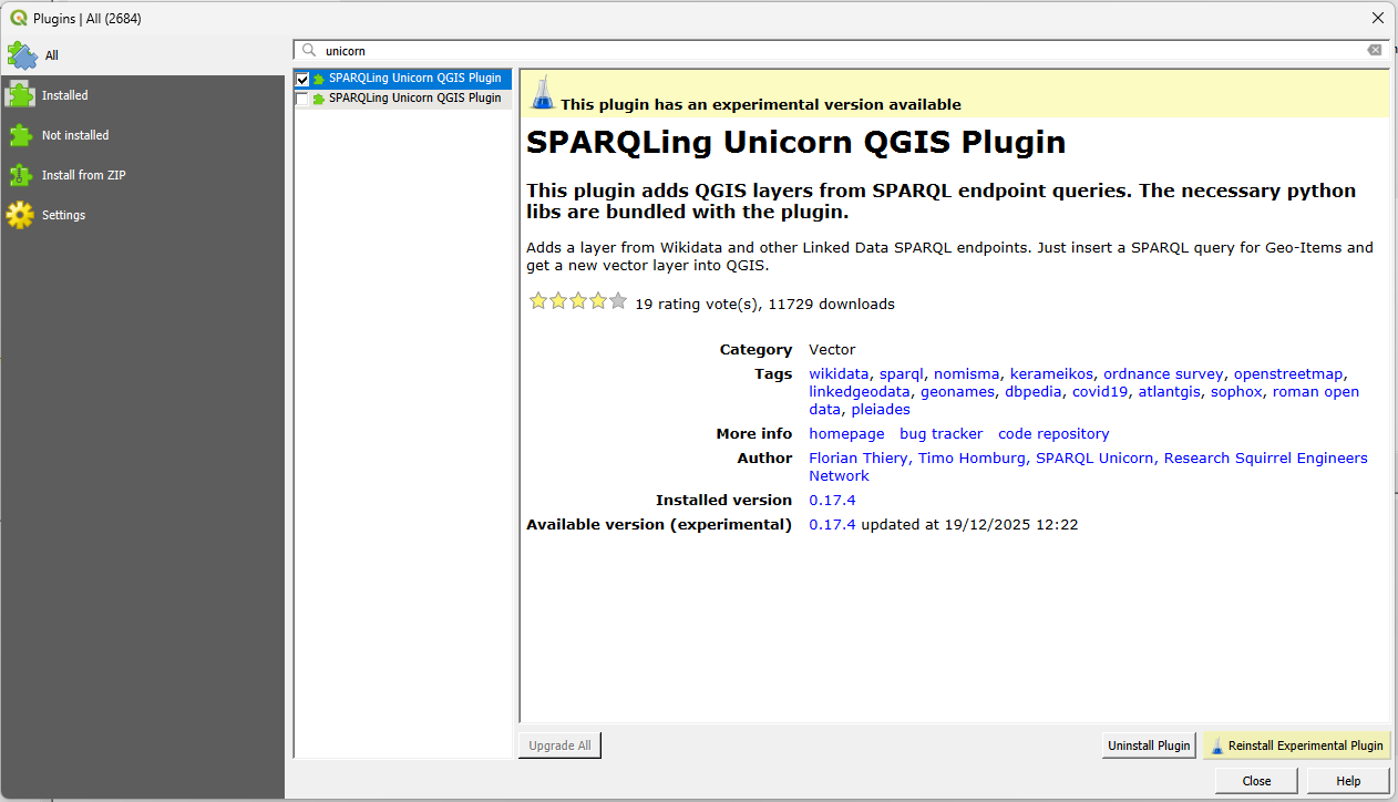
Install the SPARQLing Unicorn QGIS Plugin
Queries
This page collects example SPARQL queries for the SPARQLing Unicorn QGIS Plugin across four endpoints of increasing specificity:
- Wikidata — general-purpose, community-curated knowledge graph.
- FactGrid — Wikibase instance for historical research, ideal to transfer Wikidata skills to a domain context.
- Nomisma.org — domain-specific vocabulary and data hub for numismatics, built on a custom ontology (
nmo:). - NFDI4Objects Knowledge Graph — research infrastructure for object-related data in archaeology, accessed per named graph (
collection/*).
Each query can be pasted directly into the plugin’s query editor (Linked Data Processing → Concept Query) and executed against the endpoint given at the top of each section. Where the plugin is GeoSPARQL-aware, the ?geo, ?wkt, or ?lat/?lon variables are auto-detected and the results are rendered as a QGIS vector layer.
Wikidata — Ogham stones on the Dingle peninsula
Endpoint: https://query.wikidata.org/sparql
A worked example from the Linked Open Ogham project (Schmidt & Thiery 2022): all CIIC-catalogued Ogham stones (wd:Q72617071) that are part of the Corpus Inscriptionum Insularum Celticarum (wdt:P361 wd:Q100530634) and administratively located on the Dingle peninsula (wdt:P131 wd:Q59419929). The SERVICE wikibase:label block adds a localised ?itemLabel automatically — a Wikibase-specific convenience that saves an explicit rdfs:label triple with a language filter.
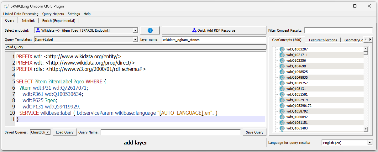
SELECT ?item ?itemLabel ?geo WHERE {
  ?item wdt:P31 wd:Q72617071;
    wdt:P361 wd:Q100530634;
    wdt:P625 ?geo;
    wdt:P131 wd:Q59419929.
  SERVICE wikibase:label { bd:serviceParam wikibase:language "[AUTO_LANGUAGE],en". }
}
Wikidata — Holy Wells in Ireland
Endpoint: https://query.wikidata.org/sparql
The second Wikidata example queries Holy Wells curated by the Research Squirrel Engineers’ WikiProject HolyWells. It returns every item typed as Holy Well (wd:Q1371047) located in Ireland (wd:Q27) and named after a female saint (wdt:P21 wd:Q6581072) — swap in wd:Q6581097 to flip to male saints. The result is ordered by ?namedAfterLabel, which groups stones by their patron saint in the QGIS attribute table.
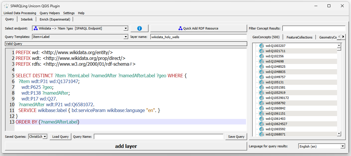
SELECT DISTINCT ?item ?itemLabel ?namedAfter ?namedAfterLabel ?geo WHERE {
  ?item wdt:P31 wd:Q1371047;
    wdt:P625 ?geo;
    wdt:P138 ?namedAfter;
    wdt:P17 wd:Q27.
  ?namedAfter wdt:P21 wd:Q6581072.
  SERVICE wikibase:label { bd:serviceParam wikibase:language "en". }
}
ORDER BY (?namedAfterLabel)
FactGrid — historical sites in Koblenz
Endpoint: https://database.factgrid.de/sparql
FactGrid is a Wikibase instance, so properties are P… but with their own IDs distinct from Wikidata. This query is taken from the FactGrid Mapping Koblenz project and returns every FactGrid item administratively located in Koblenz (wd:Q922978), together with its type (P2) and its coordinate (P48). The type label becomes the ?layerLabel and can be used to colour the resulting points in QGIS by category.
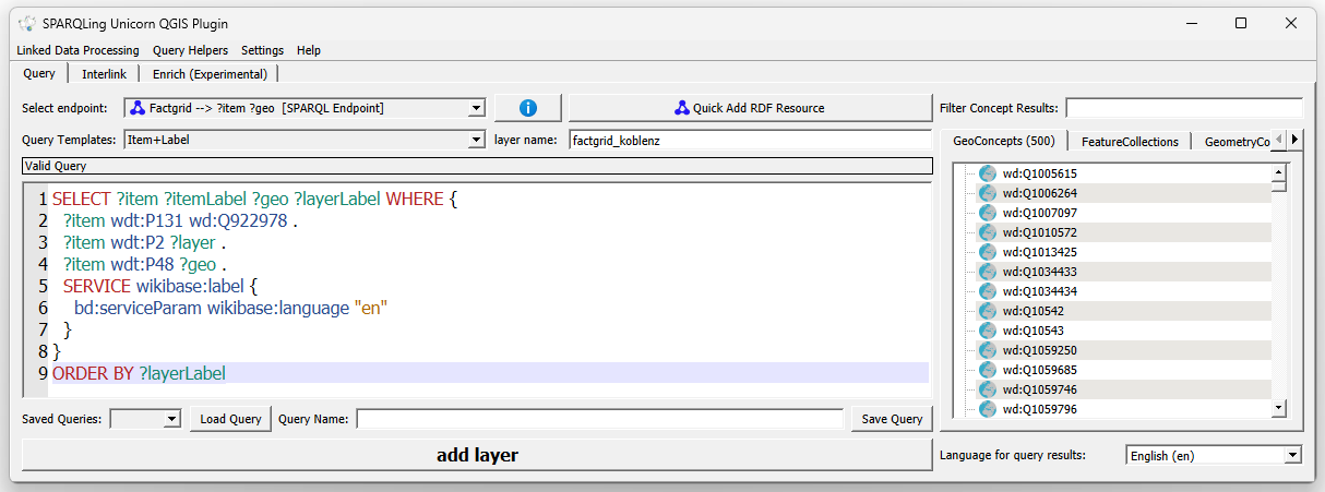
SELECT ?item ?itemLabel ?geo ?layerLabel WHERE {
  ?item wdt:P131 wd:Q922978 .
  ?item wdt:P2 ?layer .
  ?item wdt:P48 ?geo .
  SERVICE wikibase:label {
    bd:serviceParam wikibase:language "en"
  }
}
ORDER BY ?layerLabelThe wdt: prefix above points to FactGrid’s property namespace, not Wikidata’s — even though the local name (P131, P48) overlaps visually. When you adapt a Wikidata query to FactGrid, you always need to re-check each property ID against FactGrid’s own property catalogue.
FactGrid — pharmacies in Koblenz
Endpoint: https://database.factgrid.de/sparql
A narrower query from the same Mapping Koblenz project: every pharmacy (P280 = wd:Q480860, is a: pharmacy) operated by a pharmacist (P47 = wd:Q10399) and located in Koblenz. Unlike the Koblenz overview above, wdt:P48 ?geo is mandatory here — pharmacies without a geo-reference are filtered out, so every row in the result maps to a point in QGIS.
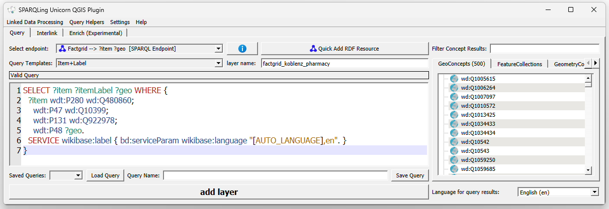
SELECT ?item ?itemLabel ?geo WHERE {
  ?item wdt:P280 wd:Q480860;
    wdt:P47 wd:Q10399;
    wdt:P131 wd:Q922978;
    wdt:P48 ?geo.
  SERVICE wikibase:label { bd:serviceParam wikibase:language "[AUTO_LANGUAGE],en". }
}
Nomisma — all mints
Endpoint: https://nomisma.org/query
Nomisma uses its own ontology (nmo:) rather than Wikibase-style properties. A nmo:Mint is any entity that minted coins, and its geographical position comes via the standard WGS84 vocabulary. This query returns every mint concept defined in Nomisma together with its latitude and longitude — a good first query to get a feel for the geographical coverage of the vocabulary.
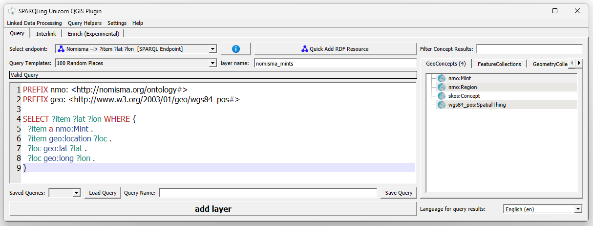
PREFIX nmo: <http://nomisma.org/ontology#>
PREFIX geo: <http://www.w3.org/2003/01/geo/wgs84_pos#>

SELECT ?item ?lat ?lon WHERE {
  ?item a nmo:Mint .
  ?item geo:location ?loc .
  ?loc geo:lat ?lat .
  ?loc geo:long ?lon .
}
Nomisma — coin findspots in Northamptonshire
Endpoint: https://nomisma.org/query
The second Nomisma query reaches into the actual specimen data contributed by partner projects (the British Museum, PAS, and others). It pulls numismatic objects whose findspot falls within Northamptonshire (wikidata:Q23115) via a transitive CIDOC-CRM path (crm:P89_falls_within+), together with their type series item and end date. The date field is then available in QGIS as a graduated symbology attribute, giving the chronological distribution of coin finds across the county.
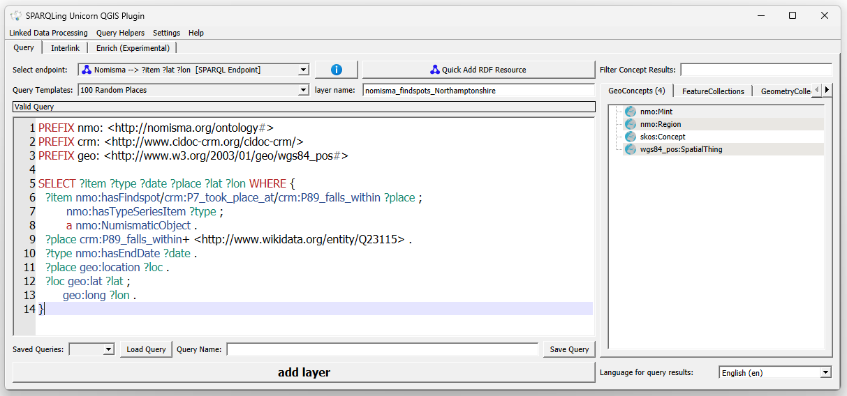
PREFIX nmo: <http://nomisma.org/ontology#>
PREFIX crm: <http://www.cidoc-crm.org/cidoc-crm/>
PREFIX geo: <http://www.w3.org/2003/01/geo/wgs84_pos#>

SELECT ?item ?type ?date ?place ?lat ?lon WHERE {
  ?item nmo:hasFindspot/crm:P7_took_place_at/crm:P89_falls_within ?place ;
        nmo:hasTypeSeriesItem ?type ;
        a nmo:NumismaticObject .
  ?place crm:P89_falls_within+ <http://www.wikidata.org/entity/Q23115> .
  ?type nmo:hasEndDate ?date .
  ?place geo:location ?loc .
  ?loc geo:lat ?lat ;
       geo:long ?lon .
}
NFDI4Objects KG — Ogham stones with MAQI inscriptions
Endpoint: https://graph.nfdi4objects.net/api/sparql
The NFDI4Objects Knowledge Graph partitions its content into named graphs, one per collection. Ogham-related research data is imported via the Ogham ontology (oghamonto:). This query returns every CIIC Ogham stone whose inscription reading contains the token MAQI (Old Irish maq(q)i, “son of”) — one of the most frequent formulaic elements on Ogham stones, and a good filter to highlight genealogically relevant inscriptions across Ireland.
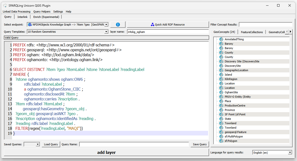
PREFIX rdfs: <http://www.w3.org/2000/01/rdf-schema#>
PREFIX geosparql: <http://www.opengis.net/ont/geosparql#>
PREFIX ogham: <http://lod.ogham.link/data/>
PREFIX oghamonto: <http://ontology.ogham.link/>
SELECT DISTINCT ?item ?geo ?itemLabel ?stone ?stoneLabel ?readingLabel
WHERE {
  ?stone oghamonto:shows ogham:OW6 ;
         rdfs:label ?stoneLabel ;
         a oghamonto:OghamStone_CIIC ;
         oghamonto:disclosedAt ?item ;
         oghamonto:carries ?inscription .
  ?item rdfs:label ?itemLabel ;
        geosparql:hasGeometry ?geom_obj .
  ?geom_obj geosparql:asWKT ?geo .
  ?inscription oghamonto:identifiedAs ?reading .
  ?reading rdfs:label ?readingLabel .
  FILTER(regex(?readingLabel, "MAQI"))
}
NFDI4Objects KG — ArNO (Poseidon) aDNA samples per site
Endpoint: https://graph.nfdi4objects.net/api/sparql
The ArNO (Archaeo-Natural Objects) dataset from Project Poseidon lives in collection/17 and links aDNA samples to their discovery sites and administrative context. This query aggregates sample counts per site, carrying along the country label and the geometry — a good template for any sample-per-site aggregation over the NFDI4Objects graph.
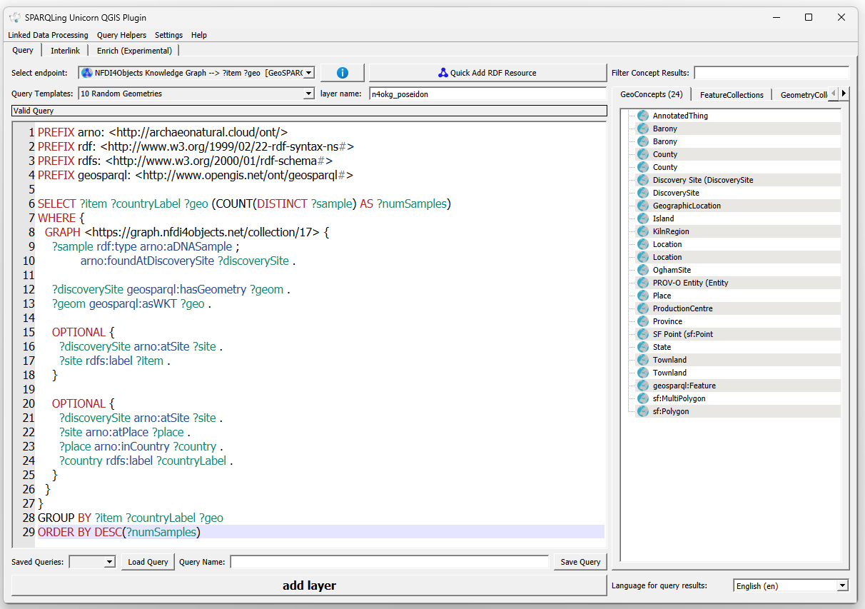
PREFIX arno: <http://archaeonatural.cloud/ont/>
PREFIX rdf: <http://www.w3.org/1999/02/22-rdf-syntax-ns#>
PREFIX rdfs: <http://www.w3.org/2000/01/rdf-schema#>
PREFIX geosparql: <http://www.opengis.net/ont/geosparql#>

SELECT ?item ?countryLabel ?geo (COUNT(DISTINCT ?sample) AS ?numSamples)
WHERE {
  GRAPH <https://graph.nfdi4objects.net/collection/17> {
    ?sample rdf:type arno:aDNASample ;
            arno:foundAtDiscoverySite ?discoverySite .

    ?discoverySite geosparql:hasGeometry ?geom .
    ?geom geosparql:asWKT ?geo .

    OPTIONAL {
      ?discoverySite arno:atSite ?site .
      ?site rdfs:label ?item .
    }

    OPTIONAL {
      ?discoverySite arno:atSite ?site .
      ?site arno:atPlace ?place .
      ?place arno:inCountry ?country .
      ?country rdfs:label ?countryLabel .
    }
  }
}
GROUP BY ?item ?countryLabel ?geo
ORDER BY DESC(?numSamples)